Rebellious river: Chinese hydropower development in an illegible landscape
Rebellious river: Chinese hydropower development in an illegible landscape
Nicholas Lo, MESc 20191
Abstract
Some of the most prominent forms of Chinese investment overseas are the large-scale hydropower dams that radically transform river systems. This essay explores how the topography of the Salween River basin in Burma creates a geographic space that is less conducive for state-making projects, while also making the basin a target of state-centric development masterplans. Building large dams on the Salween would not only have major ecological impacts, but also would reshape territorial relations between the Burmese military and ethnic armed resistance groups, as well as affecting indigenous people’s lifeways in the basin. The Chinese state’s imposition of national boundary lines on the Salween in environmental policy, disassembling the river into discrete units and disassociating transboundary impacts, showcases how the top-down gaze of state planners often fails to reckon with the socio-ecological realities of a given landscape. The illegible terrain of the Salween River basin’s highlands, in terms of its history of territorial conflict and political volatility, creates obstacles for the Chinese hydropower development apparatus—such state actors fail to take into account the contemporary legacies of the Salween River basin’s geographically and politically sedimented history of state and corporate violence against people and the environment.
Introduction: Remoteness, lost
”While all was dark and gloomy in the depth of the valley, the setting sun caught the tops of the mountains across the river, and one forgot their bare brown slopes under the waves of crimson light which they reflected. Gradually a deep blue shadow crept up out of the valley and wrapped the hills in slumber, while a soft clinging mist seemed to precipitate itself from the atmosphere and spread over the rice-fields far below. In the gloaming the crimson died down to purple, the purple became violet, and still the glorious colours of sunset played up and down the valley.”
Francis Kingdon Ward 1913: 236
Over a hundred years ago, Francis Kingdon Ward trekked up and down the great watersheds of the Salween, the Mekong, the Yangtze, and the Irrawaddy. Starting from colonial Rangoon, he would make his way up the Irrawaddy to Bhamo, then head eastwards along the Shweli to reach the Shan hills of Yunnan to find the Salween (Fig. 1). Yet long before white men ever set foot there, the Salween highlands were the site of trade and friction, caught between the orbits of Burma, Tibet, and China, where cultural boundaries were porous and the state had a weaker grip—as the traditional Chinese saying goes, tian gao, huangdi yuan—the heavens are high and the emperor is far away. Things have changed in the 21st century, as states have begun the enclosure of one of the last free-flowing rivers of Asia.
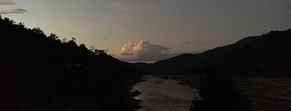
Fig. 1. Salween River at dusk, Thai-Burma border. Credit: N. Lo.
This essay explores how the geography of the Salween River has on one hand endowed the river with socio-ecological qualities not conducive to state-making (cf. Scott 2009), but has on the other hand in recent decades made the Salween a target of modern state-building projects—on both sides of the Sino-Burmese border—that seek to harness the river’s power. The imposition of national boundary lines on a river, disassembling it into discrete units and disassociating transboundary impacts, showcases how the top-down gaze of state planners often fails to reckon with the socio-ecological realities of terrain and landscape.
My in-depth interviews with environmental activists and indigenous and minority rights advocates in Burma often turned to the impacts of Chinese infrastructure, particularly hydropower dams on the Irrawaddy and Salween Rivers. This essay builds off of work done before beginning my research at Yale, combining desk research, field interviews, and cartographic visualizations of patterns of infrastructure development, conflict, and environmental degradation. Due to the fact that access to dam sites on the Salween River basin is restricted by the Burmese military, my primary data is largely derived from interviews with activists and NGO staff in cities in Burma and elsewhere in the region, including Thailand and China.
The Salween, resistant to state-making
Historically, as a result of the remoteness of the Yunnan highlands on the eastern edge of the Himalayan massif, other major rivers of the great Himalayan watershed like the Salween attracted much less attention from the Chinese state. Beginning in the 2000s, the government sought to develop the hydropower resources of the Salween River. After 15 years of anti-dam campaigning by Chinese environmentalists, the government is now planning on creating a national park for the “Nu River Grand Canyon.” Yet south of the border in Myanmar, Chinese developers’ plans to build the large dams on the Salween are still live, though they have been stalled by the continuous outbreak of armed conflict in Shan State and Karen State (see Fig. 2).
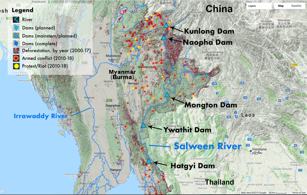
Fig. 2. Map of Salween Basin, Myanmar/Burma. Map of Salween River across Myanmar/Burma, with information obtained from the following sources: conflicts (ACLED), dams (IFC), deforestation (Hansen), rivers (MIMU). Credit: N. Lo & T. Huang, Yale University, 2019.
The geography and history of the Salween are integral factors in determining the politics of the present day. The Salween River originates in the Tanggula Mountains on the Tibetan Plateau, where the Salween’s tributaries meander down and winds its way through Kham in eastern Tibet. From Tibet, the Salween heads southwards to find its way into the Three Parallel Rivers area of Yunnan Province (Yu et al. 2018). By the time the Salween reaches Yunnan, it is known as the Nujiang in Chinese, or “angry river.” Further south, as the mountains and gorges give way to hills, the Salween River valley enters the realm of the former Shan statelets, extending across southwest Yunnan and northern Burma; there, the saophas, Shan nobles, ruled multi-ethnic polities based on wet-rice cultivation (Scott 2009; Giersch 2006; Leach 1960).
The Salween then meanders through the subtropical jungle maze of the Karenni and Karen hills, snaking along the border with Thailand, where Karen-affiliated nationality groups have traditionally practiced swidden cultivation. After the British invaded and occupied Burma in the 1850s, these forests were heavily logged for valuable teak, (Bryant 1996; 1994). Out of the hills, the Salween heads southwards, meandering across its floodplain, past Hpa-an, capital of Karen State. Further south in the floodplain, agrarian communities in Karen State are dependent on the Salween itself for its rich fisheries as the river winds past the city of Mawlamyine, formerly known as Moulmein, emptying out at the Gulf of Martaban in the Andaman Sea (Aung 2017).
Gorge-like or hilly throughout most of its length and bereft of a major floodplain until the last few hundred kilometers, the Salween is perhaps not as well-known as its neighboring rivers due to its low population and relative remoteness from expansionist states. This kind of natural “illegibility” has proven fortuitous for the Salween’s ecology, for the time being (Scott 2009, 1998). In the past, steep gorges prevented the watershed from being extensively logged (Moore 2007), and clearing of tree and vegetation cover was largely carried out as part of swidden rotation cycles, leaving a largely undisturbed montane landscape between Tibet and the Shan hills, home to all manner of diverse fauna like the recently ‘discovered’ snub-nosed monkeys.
The combination of complex cultural histories and variegated mountainous terrain, both carved out by the Salween and its tributaries, and competing claims over natural resources, have created a volatile, fluid sociopolitical terrain that is resistant to rigid state claims over territory. Presently, the Salween River basin is populated largely by peoples that are typically referred to by the relevant state (Chinese, Thai or Burmese) as ethnic minorities, hill tribes, or ethnic nationalities. All of these terms are loaded with meanings that are specific to each state yet carry the same general connotation of being “backwards” and “savage” —living off the land through hunting and foraging and swidden cultivation is interpreted by state actors as signs of primitiveness. For the Chinese state, its ethnic minority populations’ lack of “civilization” and material “impoverishment” needed to be rectified through “development” (Harwood 2013; Harrell 1995).
Crucially, the Salween has not been significantly altered by large-scale engineering along the entirety of its length, with the exception of two small dams on its tributaries in Tibet, making it one of the last free-flowing great rivers of Asia (McDonald 2007). However, this has not prevented the Chinese and Burmese states from exerting their control over the Salween River valley. Communities along the Salween in Shan, Karenni and Karen States have been subject to extreme violence, intensive resource extraction and militarization since the colonial era, with teak and ironwood being the most desirable commodities. This rampant extraction of natural resources continues under the oversight of the Burmese military, known as the Tatmadaw (Woods 2011; Smith 1991). Today, the value that states hope to extract from the Salween landscape is hydropower. The developmentalist mindset that the Chinese state actors have brought to the Salween is emblematic of “state simplification”—as James Scott notes, these schemes often bring about disastrous results (1998: 4).
River enclosure movement
Since the Communist Party’s consolidation of China’s peripheries during the 20th century, remote rivers like the Salween have become much more valuable to the state. In their infrastructural masterplans, Chinese state developers have imposed a series of artificial boundaries on the ecological impacts of their activities, a perhaps intentional form of ignorance that devalues the Salween River’s existence as a functioning, contiguous system that flows without interruption, shaping the landscape and the humans and nonhumans who live in it.
Over the course of its run from its source through Tibet and China, the Salween experiences a drop in elevation of approximately 5,000 meters—according to Chinese government estimates, harnessing all of this water with a thirteen-dam cascade would produce more 21,000 MW, over 3,000 MW more than the Three Gorges Dam (Magee & McDonald 2006). If this initial plan had progressed any further, up to 80,000 people would have been relocated out of the Salween River valley in Yunnan (ERI 2004). Unlike the fate of many other rivers in China, there has been substantial public debate over the future of the Salween’s continued flow. Since the Salween River campaign in China has been documented extensively by various scholars 2, I will briefly note that the Salween campaign became one of the most well-known environmental disputes in China’s public sphere. The Chinese state has now removed the Salween River hydropower dams from its list of major infrastructure projects in its 13th Five Year Plan (Bosshard 2016; Leavenworth 2016). Instead, the Chinese government is planning on creating a national park—the Nu River Grand Canyon National Park—as part of the nationwide effort to construct an “ecological civilization.” (Li 2017a; Jing 2016).
Yet this aspiring ecological civilization is also financing the construction of large-scale dams downstream, south of the border, on the very same river. In the name of helping to electrify the Burmese hinterland and develop Burma’s national economy as “South-South cooperation” (Yeh 2016), the Chinese government and its state-owned hydropower enterprises inked deals with the then-military regime to construct six dams on the main stem of the Salween: the Kunlong and Naopha dams in northeast Shan State, Mongton dam in southern Shan State, Ywathit dam in Karenni State and Hatgyi dam in Karen State (see Fig. 2; SWC 2016).
By attributing downstream dam plans to the Burmese government’s prerogative, placing artificial national boundaries on the Salween River allows Chinese state actors to disassociate the government’s protection of the Salween upstream in China from Chinese hydropower corporations’ impacts on ecology and communities downstream in Burma—as if the Salween in Burma was an entirely distinct entity from the Salween in China. This artificial disaggregation serves the interests of the Chinese state, which is looking for a spatial fix for its excess construction capacity, and those of the Burmese state, which is looking to consolidate its grip on peripheral territories. There are a couple strands to follow here: 1) the constructed boundaries of ecological impacts, and 2) the ignorance of socio-political contexts abroad.
Constructed boundaries of socio-ecological impacts
The fate of the Salween remains unclear, though anti-dam advocates are holding out hope that the Burmese civilian government led by the National League for Democracy will be able to live up to its manifesto, and reconsider the infrastructure development deals signed under the former military junta (Naing 2016). Even in China, environmental activists are waiting to see what the state’s next moves are with regards to the Salween. However incongruous it seems, local provincial officials do not see the establishment of a national park and the construction of dams in the same river valley as being mutually exclusive (Yu et al. 2018; Liu 2017a). The imposition of an arbitrary boundary on where protected areas “end” may lead to distorted decision-making processes that neglect the contiguous systems between the river and its surrounding riparian forests and mountains (International Rivers 2016).
The developmental gaze that Chinese state actors apply to the Salween River is distorted by these politically constructed boundaries. As with the Chinese dams on the Mekong, which millions and millions of people rely on for their livelihoods in Southeast Asia, the Chinese state maintains a massive imbalance in power in relation to downstream nations like Burma (Middleton & Allouche 2016). Chinese state-owned power generation companies are attempting to move forward with their hydropower development plans downstream in Burma in the name of “clean energy,” but the economic rationale behind such massive hydropower dams is unclear.
The Salween dam deals were signed either before or in 2010, and the Burmese government’s initial plan was to export the majority of electricity generated to China. Currently, with China’s macro-economic slowdown, electricity demand has not grown apace with electricity production (Magee & Hennig 2017). The likelihood of Myanmar dams selling electricity to Yunnan is low, as the latter is already at overcapacity with its own hydropower production and is looking to export excess generation to other countries (Lin 2017; Liu 2017b). Most recently, Burma’s new energy minister U Win Khaing even expressed doubts about moving forwards with the large hydropower schemes (Lewis & Naing 2017).
Chinese hydropower developers’ decisions to push ahead with dam plans on the Salween in Burma appear to be driven by either hubris or ignorance. Much blood has been shed in the Salween basin in Burma, as the Tatmadaw clashed alternately with the Karen National Liberation Army, the Communist Party of Burma, the Shan State Army-North, the Shan State Restoration Council, as well as dozens of other ethnic armed resistance groups, over the course of seven decades (Raleigh 2018; Smith 2007, 1991; see Fig. 3 and 4 for visualization of conflict since 2010-2018). The Salween River basin has also proven to be sanctuary for peripheral peoples fleeing military oppression. Hundreds of thousands of Karen, Shan and Karenni people have lived in refugee camps on the Thai side of the Salween for decades, waiting for the last embers of war to be snuffed out before they ever set foot in Burma again (Thwe 2003).
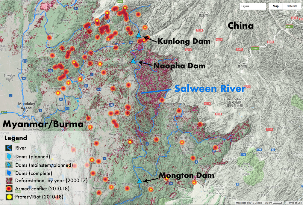
Fig. 3. Map of Salween Basin (Upper), Myanmar/Burma. Map of Salween River in Shan State. Credit: N. Lo & T. Huang, Yale University, 2019.
It is in this context that I first took a trip up the Salween to cross over to Mutraw (Papun) District, the northernmost corner of Karen State, largely still under the control of the 5th Brigade of the Karen National Union. On the way upstream, we pass by a wooden sign nestled in the vegetation on the western shore. “NO DAM.” My activist colleagues told me it was from several years prior, when they mobilized Karen communities to protest against the Hatgyi dam, which would have flooded the refugee camps along the river. Chinese dam developers had walked blindly into the politically volatile and historically charged landscape of the Salween.
Hydropower and war along the Salween River
Up and down the Salween, conflict has derailed developers’ plans. Grassroots and community-based groups have drawn links between the militarization of ethnic nationality-populated uplands of Burma with the various hydropower dam projects on the Salween3. Violence broke out near the Hatgyi dam site between one of the Karen armed groups and the Tatmadaw in October 2014 and September 2016, leading to the displacement of thousands of Karen villagers (Interview, Yangon 2018; see Fig. 4). At the Ywathit dam in Karenni State, Chinese engineers were killed in 2010 by a Karenni resistance group (Mang & Yan 2013), while the outbreak of fighting between Kokang and Ta’ang armed groups and the Tatmadaw in 2015 halted the Kunlong dam’s preparatory work (Shin 2015; see Fig. 3). Progress on all of the Salween dams has stalled around the dam sites due to security concerns, including the kidnapping of Chinese engineers near the Mongton dam (Interview, Chiang Mai 2018).
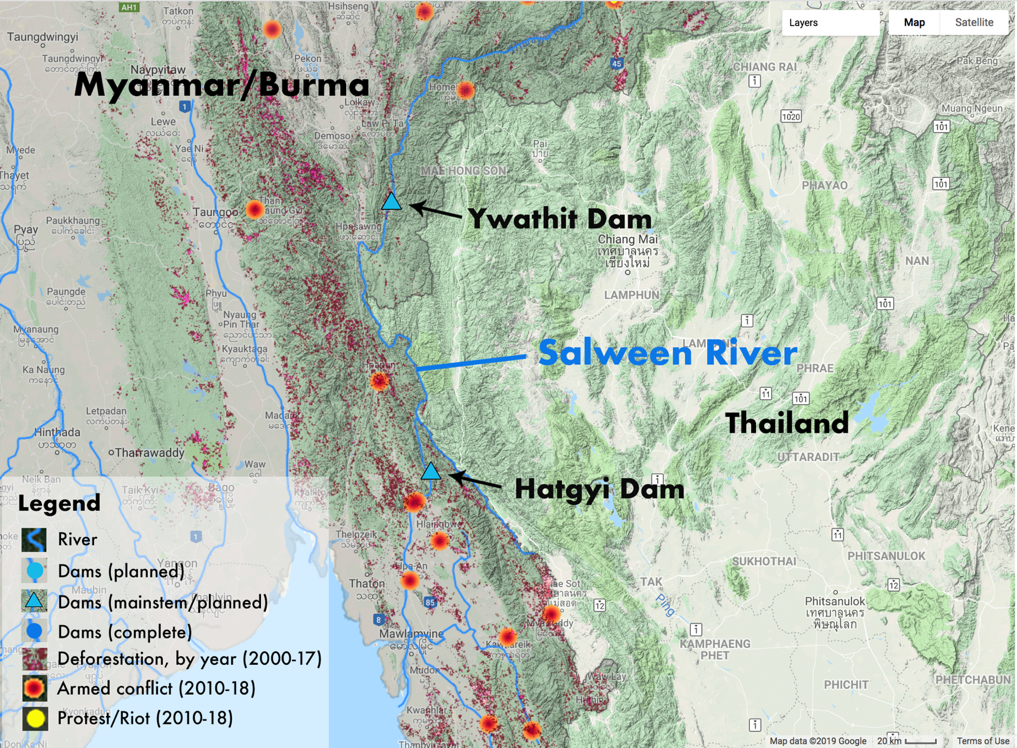
Figure 4. Map of Salween Basin (Lower), Myanmar/Burma. Map of Salween River in Karenni/Kayah State and Karen/Kayin State. Credit: N. Lo & T. Huang, Yale University, 2019.
It would be too simplistic to say that the Chinese state does not care at all about the downstream impacts of its activities, or that the Chinese investors can simply overcome a “weak state” (Lu 2017). As many observers have pointed out, the problem is not only Chinese corporations—governments like Burma are willing receivers of Chinese capital, but do not have the regulatory capacity to manage the socio-environmental impacts of such large-scale development projects (Interview, Yangon 2018; Lamb & Dao 2017). According to one informant, the Burmese government staff at the Environmental Conservation Department, in charge of reviewing environmental impact assessments, could not understand the detailed, dense English reports submitted by corporations and the IFC (Interview, Taunggyi 2018).
Yet what is more pertinent to my inquiry here is how the Chinese state actors have embroiled themselves in a variety of controversies without understanding how they arrived there in the first place. In his adaptation of Ferguson’s “anti-politics machine” (1990) to the Myitsone dam ‘incident,’ as it referred to in Chinese, anthropologist Laur Kiik describes how the hydropower developers did not foresee how China’s poor reputation in Burma—a result of the Chinese government’s ongoing support for both non-state armed groups and the Burmese military—could possibly weigh down the dam project with political baggage. Public protest, among other factors, led to the Burmese government’s suspension of the 3.6 billion USD Myitsone dam project in 2011, shocking China (Kiik 2016).
Nevertheless, in spite of fierce opposition from civil society and local communities, Chinese state actors have quietly continued their operations on these Burmese Salween projects. Activistsin Shan State pointed out how Chinese developers failed to take into account any of affected people’s perspectives for years, resulting in highly visible and media-savvy protests at the few public consultations that took place in 2015 (Interview, Taunggyi 2018). According to these informants, teams of Chinese engineers have returned to the Mongton dam site to conduct unknown surveys—there is little clarity on the ground because access has been restricted by the Burmese military (Interview, Taunggyi 2018). Just as recently as May 2018, a Shan villager had been fatally shot by the Burmese military while traveling down the river near the Mongton dam—a grim testimony to the lingering insecurity and lawlessness in the borderlands where Chinese hydropower dams are planned (Interview, Chiang Mai 2018; Yee 2018). Though realities on the ground are hard to extricate from rumors, it is clear that the Chinese state-led development model has not been very successful in the Salween.
When it arrives in the Salween River basin, the Chinese hydro-development apparatus is unequipped to deal with fragile political situations, and exacerbates the ongoing violence by facilitating the expansion of Burmese state power. My informants said that the Chinese hydropower developers primarily worked with the Ministry of Electricity and Energy, sidelining other stakeholders whose views did not align with their own (Interview, Taunggyi 2018). Though the Chinese state is responding to the Myitsone dam suspension and other Chinese-led development projects’ poor reputation by issuing a number of regulatory guidelines to improve social and environmental standards for overseas investments (International Rivers 2013), this effort seems disingenuous. The Chinese state-owned conglomerates responsible for developing the Mongton dam have not changed their secretive practices—instead of engaging with the local communities around the Wan Hsa La area, the engineers are escorted around by the very same military units that have terrorized local populations for decades (Interview, Taunggyi 2018). Though the Chinese corporation perceives its collaboration with the military junta of Burma as a neutral and apolitical form of infrastructure service-delivery, in reality, the Burmese regime is in the proactive process of subjugating ethnic armed resistance across the nation with Chinese-supplied arms, reaching into remote territories with Chinese-paved roads.
Conclusion: Subversive spaces along a rebellious river
In the “Ecological and Environmental Cooperation Plan” for China’s Belt and Road Initiative (MEP 2017), the Chinese state’s conception of an ecological civilization is not one that perceives socio-ecological systems through a holistic lens—rather, it is an eco-modernist framework that defines development according to the agendas and perspectives of top-down authoritarian planners and myopic bureaucrats—never the people whose lives and homes are transformed (Chen et al. 2017; Chen 2013). This kind of depoliticized, distorted sustainable development ideology allows the Chinese state to export destructive, large-scale infrastructure development projects and then follow through with performative corporate social responsibility programs throughout Burma, obscuring and eliding the grievances of ethnic communities against the Burmese military’s atrocities.
These contradictions and disjunctures are the result of an apolitical development apparatus coming into contact with the variegated sociopolitical terrain of the Salween basin and running into trouble. From the Sinocentric perspective, as an ‘advanced’ civilization, Chinese state developers see themselves sharing China’s developmental path with its poorer neighbors, including Burma. Their myopia leads developers to assume that if people are resisting hydropower development, it is because they are uneducated and do not understand the benefits of hydropower, not that the people simply do not want to leave their land—the Chinese state-making project is something that is perceived as inherently benevolent, bringing order, harmony and development to the unruly peripheries. These narratives are not borne out in the real world, and especially not in the Salween River basin, where people are refugees and survivors who have managed to avoid successive empires and states.
The Chinese state’s willful ignorance of and perhaps its incapability to address the socio-ecological realities of the Salween, and other locales, will set itself up for failure. Caught between empires of violence and hegemonies of knowledge, subversive spaces like the Salween that give rise to resistance and counter-narratives will persist. Out of these territories of struggle, people continue to fight against the seemingly hegemonic forces of development and modernization, complicating the state’s linear narratives by telling their truths from the ground, and their stories from the river.
Acknowledgements
This essay came out of my research into the environmental politics of Chinese infrastructure development in Burma, supported by the Tropical Resources Institute and MacMillan Center at Yale University.
References
Aung, C. 2017. Thanlwin-Nu-Salween estuary: Threats challenging brackish water fisheries. Center for Sustainable Development Studies. Chulalongkorn University.
BEWG. See Burma Environmental Working Group.
Bosshard, P. 2016, Dec 1. Press release: Great news for China’s last free-flowing river. [Online]. International Rivers. Available at: https://www.internationalrivers.org/resources/press-release-great-news-f….
Bryant, R.L. 1996. Romancing colonial forestry: The discourse of ‘forestry as progress’ in British Burma. Geographical Journal, 169-178.
Bryant, R.L. 1994. From Laissez-faire to scientific forestry: Forest management in early colonial Burma, 1826-85. Forest & Conservation History, 38, 160-170.
Burma Environmental Working Group, 2017. Resource Federalism: A roadmap for decentralised governance of Burma’s natural heritage.
Burma Environmental Working Group, 2011. Burma’s Environment: People, problems, policies.
Burma Environmental Working Group, 2009. Accessible Alternatives: Ethnic communities’ contribution to social development and environmental conservation in Burma.
Chen, J.C. 2013. Sustainable territories: Rural dispossession, land enclosures and the construction of environmental resources in China. Human Geography, 6, 102-118.
Chen, J.C., Zinda, J.A. and Yeh, E.T. 2017. Recasting the rural: State, society and environment in contemporary China. Geoforum 78, 83-88.
EarthRights International, 2004. The Lancang/Mekong and the Nu/
Salween rivers: Promoting regional watershed governance and distributive justice for downstream Burmese communities. UN Symposium on Hydropower & Sustainable Development.
EarthRights International & Karen Environmental and Social Action Network, 2003, Oct. Capitalizing on Conflict: How logging and mining contribute to environmental destruction in Burma.
ERI. See EarthRights International.
Ferguson, J. 1990. The Anti-politics Machine: ‘Development’, Depoliticization and Bureaucratic Power in Lesotho. University of Minnesota Press.
Fiskesjš, M. 1999. On the ‘raw’ and the ‘cooked’ barbarians of imperial China. Inner Asia, 1, 139-168.
Giersch, C.P. 2006. Asian Borderlands: The Transformation of Qing China’s Yunnan Frontier. Harvard University Press.
Harrell, S. (ed.) 1995. Cultural Encounters on China’s Ethnic Frontiers. University of Washington Press.
Harwood, R. 2013. China’s new socialist countryside: modernity arrives in the Nu River Valley. University of Washington Press.
Ho, P. and Edmonds, R. eds. 2007. China’s embedded activism: Opportunities and constraints of a social movement. Routledge. International Rivers 2016. Overlooked plant biodiversity in low-altitude areas of the Nu River valley. [Online]. Available at: https://www.internationalrivers.org/nuriver2016.
International Rivers 2013. Chinese government guidelines for overseas investment. [Online]. Available at: https://www.internationalrivers.org/resources/chinese-government-guideli….
Jing, L. 2016. China’s Grand Canyon: no more small hydropower plants for country’s last wild river in scenic Yunnan. South China Morning Post. [Online]. Available at: http://www.scmp.com/news/china/policies-politics/article/1925053/chinas-….
Karen Rivers Watch 2016, Sep. The Real Motivations behind Renewed War.
Karen Rivers Watch 2014, Nov. Afraid to Go Home: Recent violent conflict and human rights abuses in Karen State.
Karen Rivers Watch 2004, Nov. Damming at Gunpoint: Burma Army atrocities pave the way for Salween dams in Karen State.
Kiik, L. 2016. Nationalism and anti-ethno-politics: why ‘Chinese Development’ failed at Myanmar’s Myitsone Dam. Eurasian Geography and Economics, 57, 374-402.
KRW. See Karen Rivers Watch.
Lamb, V. & Dao, N. 2017. Perceptions and practices of investment: China’s hydropower investments in Vietnam and Myanmar. Canadian Journal of Development Studies, pp. 1-19.
Leach, E.R. 1960. The frontiers of “Burma”. Comparative Studies in Society and History, 3(1), pp.49-68.
Leavenworth, S. 2016. China may shelve plans to build dams on its last wild river. National Geographic. [Online]. Available at: https://news.nationalgeographic.com/2016/05/160512-china-nu-river-dams-e…
Lewis, S. & Naing, S. 2017. Big dams can wait, Myanmar overhauls energy strategy. Reuters. [Online]. Reuters. Available at: https://www.reuters.com/article/us-myanmar-china-energy/big-dams-can-wai….
Lin, C.T., 2017. Overcapacity forces central enterprises to offload hydropower assets in Southwest China. Yicai Global. [Online]. Yicai Global. Available at: https://www.yicaiglobal.com/news/overcapacity-forces-central-enterprises….
Lintner, B. 2015. Great game East: India, China, and the struggle for Asia’s most volatile frontier. Yale University Press.
Liu, Q. 2017a. China overhauls its national parks. ChinaDialogue. [Online]. ChinaDialogue. Available: https://www.chinadialogue.net/article/show/single/en/10152-China-overhau…
Liu, Q. 2017b. Hydro expansion will fail without energy market reform. ChinaDialogue. [Online]. ChinaDialogue. Available at: https://www.chinadialogue.net/article/show/single/en/9506-Hydro-expansio….
Lu, J. 2017. Yellow peril 2.0: A review and critique of current research and reporting on China’s rising land investments in Southeast Asia. In BRICs Initiative for Critical Agrarian Studies, The 5th International Conference of the BRICS Initiative for Critical Agrarian Studies. Moscow, Russia Oct 13-16. International Institute of Social Studies.
Magee, D. & Hennig, T. 2017. Hydropower boom in China and along Asia’s rivers outpaces regional demand. The Third Pole. [Online]. Available at: https://www.thethirdpole.net/2017/04/28/hydropower-boom-in-china-and-alo….
Magee, D. & McDonald, K. 2006. Beyond Three Gorges: Nu River hydropower and energy decision politics in China. Asian Geographer, 25, 39-60.
Mang, G. & Yan, K. 2013. China-backed dams escalating ethnic tension in Myanmar. ChinaDialogue. [Online]. ChinaDialogue. Available at: https://www.chinadialogue.net/article/show/single/en/5823-China-backed-d….
McDonald, K.N. 2007. Damming China’s grand canyon: Pluralization without democratization in the Nu River Valley. University of California, Berkeley. MEP. See Ministry of Environmental Protection.
Mertha, A.C. 2008. China’s Water Warriors: Citizen action and policy change. Cornell University Press.
Middleton, C. & Allouche, J. 2016. Watershed or Powershed? Critical Hydropolitics, China and the ‘Lancang-Mekong Cooperation Framework’. The International Spectator, 51, pp.100-117.
Middleton, C. & Dore, J. 2015. Transboundary water and electricity governance in mainland Southeast Asia. International Journal of Water Governance, 3, 93-120.
Ministry of Environmental Protection 2017. The Belt and Road Ecological and Environmental Cooperation Plan. Belt and Road Portal. [Online]. People’s Republic of China. Available at: https://eng.yidaiyilu.gov.cn/zchj/qwfb/13392.htm.
Moore, E. 2007. Buddhist archaeology on the Shan plateau: the first millennium CE. Shan Buddhism & Culture. Dec 8-9, 2007. University of London.
Naing, Y.N. 2016. Environmental advocates: Salween river is being ‘sold off’ to China. The Irrawaddy. [Online]. Available at: https://www.irrawaddy.com/news/burma/environmental-advocates-salween-riv….
Raleigh, C. 2018. Myanmar conflict update. ACLED. [Online]. Available at: https://www.acleddata.com/2018/04/05/myanmar-conflict-update/.
Sadan, M. 2016. Introduction. In Sadan, M. (ed.), 2016. War and peace in the borderlands of Myanmar: The Kachin ceasefire, 1994-2011, 1-26. Nordic Institute of Asian Studies.
Salween Watch Coalition 2016. Current Status of Dam Projects on the Salween River. [Online]. Available: https://www.internationalrivers.org/sites/default/files/attached-files/s….
Scott, J.C. 2009. The Art of Not Being Governed: An anarchist history of upland Southeast Asia. Yale University Press.
Scott, J.C. 1998. Seeing like a State: How certain schemes to improve the human condition have failed. Yale University Press.
Shan Sapawa Environmental Organization 2009. Roots and Resilience: Tasang dam threatens war-torn Shan communities.
Shan Sapawa Environmental Organization 2006. Warning Signs: Plans to dam the Salween.
Shin, A. 2015. Kunlong hydro project delayed over security concerns. Myanmar Times. [Online]. Available at: https://www.mmtimes.com/business/15422-kunlong-hydro-project-delayed-ove….
Simpson, A. 2013. Challenging hydropower development in Myanmar (Burma): Cross-border activism under a regime in transition. The Pacific Review, 26, 129-152.
Smith, M. 2007. State of strife: The dynamics of ethnic conflict in Burma. Institute of Southeast Asian Studies. Smith, M. 1991. Burma: Insurgency and the politics of ethnicity. Zed Books.
South, A. 2011. Burma’s longest war: Anatomy of the Karen conflict. Transnational Institute.
Stokes, D. 2016, Dec 7. ‘My spirit is there’: Life in the shadow of the Mong Ton dam. Mongabay. [Online]. Available at: https://news.mongabay.com/2016/12/my-spirit-is-there-life-in-the-shadow-…. SWC. See Salween Watch Coalition.
Thwe, P.K. 2003. From the Land of Green Ghosts: A Burmese Odyssey. HarperCollins UK.
Wade, G. 2000. The Southern Chinese Borders in History. In Where China Meets Southeast Asia, Evans, G., Hutton, C. and Eng, K.K. (eds.), 28-50. Palgrave Macmillan US.
Ward, F.K. 1913. The land of the blue poppy: travels of a naturalist in eastern Tibet. Cambridge University Press. Woods, K. 2016. “China in Burma”: A Multiscalar Political Economy Analysis. In Chinese Encounters in Southeast Asia: How People, Money, and Ideas from China Are Changing a Region, Nyiri, P. & Tan, D. (eds.), 157-173.
Woods, K. 2011. Ceasefire capitalism: Military–private partnerships, resource concessions and military–state building in the Burma–China borderlands. Journal of Peasant Studies, 38, 747-770.
Yee, T.H. 2018. Work on Myanmar dam goes on under heavy guard. The Straits Times. [Online]. Available at: https://www.straitstimes.com/asia/se-asia/work-on-myanmar-dam-goes-on-un….
Yeh, E.T. 2016. Introduction: The geoeconomics and geopolitics of Chinese development and investment in Asia. Eurasian Geography and Economics, 57, 275-285.
Yu, X.G., Chen, X.X., Middleton, C., Lo, N. 2018. Charting New Pathways Towards Inclusive and Sustainable Development of the Nu River Valley. Center for Sustainable Development Studies. Chulalongkorn University. [Online]. Available at: http://www.csds-chula.org/s/China_layout_final-ptp7.pdf.
Citation
Lo. N. 2019. Rebellious river: Chinese hydropower development in an illegible landscape. Tropical Resources 38, 26–37
Footnotes
-
Nicholas Lo is currently program assistant for the Rockefeller Brothers Fund’s China program. Prior to joining the RBF, Nick worked at the Stimson Center in Washington, D.C., where he researched energy infrastructure development in Southeast Asia. Previously, he worked in Thailand and Myanmar with NGOs and civil society groups in community-based natural resource management, indigenous conservation, and transboundary river governance. Nick holds a Master of Environmental Science from the Yale School of Forestry and Environmental Studies, where his thesis research and fieldwork focused on the social and environmental impacts of infrastructure investments in Southeast Asia. He also holds a Bachelor of Arts from Yale University, where he majored in global affairs with a concentration in international development.↩
-
See Magee, D. & McDonald, K., 2006.; Ho, P. & Edmonds, R., 2007; Mertha, A.C., 2008; Harwood, R., 2013; and Yu, X.G. et al., 2018, for overviews of Salween River anti-dams campaign.↩
-
For more detailed, on the ground information collected from war-displaced communities and refugees, see: Karen Rivers Watch 2016, 2014 & 2004; Shan Sapawa Environmental Organization 2009, 2006.; EarthRights International & Karen Environmental and Social Action Network, 2003.↩