
1) Where did you go for your fellowship?
I went to the Makgadikgadi region in Botswana. Makgadikgadi is in between two national parks, the Makgadikgadi Pans National Park, and the Central Kalahari Game Reserve. It is also where the Okavango Delta, the largest inland delta in the world, filters in.
2) Why did you go there?
I have been working in Southern Africa for the last 13 years now and had previous experience in Botswana. Before I started my PhD, I was working with an organization called Round River Conservation Studies on wildlife monitoring in the Okavango Delta with local community members. I was also training and working with the University of Botswana and the community trust in that region.
I had become very interested in how conservation organizations design and implement conservation plans. I had also met really fascinating people already working on the ground and so that’s kind of how I ended up here and choosing Botswana.
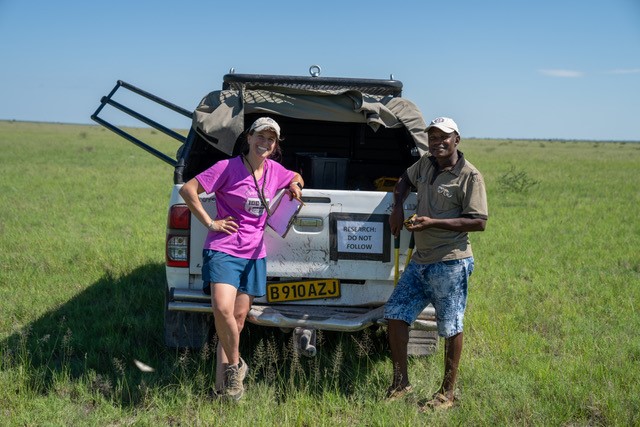
Image 1. Kaggie Orrick and colleague, Khumiso Cosmos Rathipana, in the field (Image by Dylan Feldmeier).
3) What research question were you investigating?
The Makgadikgadi region has a number of people living in this area and sits between these two national parks. It has been identified as potentially the most important corridors for lions across Southern Africa. This area is called the Kavango-Zambezi Transfrontier Area.
Although this area has been predicted to be the most important corridor, no one has been on the ground to actually confirm that lions are using it to move in between these two national parks.
So, my question is multiple parts:
1. Is this the most important corridor? Are there lions moving back and forth between this area?
2. Regardless of whether lions are moving back and forth in this area, how are people, livestock, and wildlife all using this landscape together and what sort of impact do they have on one another?
4) How did you learn about the corridor being important?
There was a beautiful paper published by the University of Oxford Wild C.R.U. (Conservation Research Unit) in 2018. In the study, they had collared lions in Zimbabwe to track their movements. They were able to determine what type of environmental and anthropogenic variables were impacting where they moved and why, including distance to roads, cattle posts, villages, etc. With this data, they predicted where corridors would be across the whole Kavango-Zambezi Transfrontier Area. They were making these well-informed predictions of where these corridors would be. But again, the next step with predictive models is to always follow up to ground truth.
So, I’ve been in communication with the Wild C.R.U. and my project is part of their next step in ground truthing their models of potential corridor areas.
5) Why do these research questions matter to you? Or to the people you were working and studying with?
I think that we can do such a better job in conservation design and planning. Oftentimes when we are designing conservation plans in these areas, we're thinking about corridors and connectivity. We do all these studies based off the traits and natural history of an animal, but we don't think about people until the later stage. In reality, especially in human dominated areas, people are influencing animals and animals are influencing people.
There are already interactions, and potentially coexistence, that are present on the landscape that aren’t necessarily incorporated into models, software programs, conservation plans or designs. And if these interactions are included, they're usually added at the very end.
So, my question has always been, how do we better incorporate people?
For the communities in the Makgadikgadi region, the international conservation community has been telling them that they should be protecting the wildlife even when there’s a lot of conflict with wildlife impacting their livelihoods quite significantly.
The reason I think it is important is, although conservation biology is moving in this direction, us conservationists could still be better about incorporating people into conservation designs and planning. And I think local community members would also appreciate being represented more significantly and being centered in conservation efforts.
6) What stage of your project are you currently in?
My project is in three parts, or methodologies almost. The first part is trying to understand the practices of people, wildlife, and livestock and how do all three of these entities move across the landscape and interact with each other to better understand how wildlife use the corridor area.
First, I have two surveys set up with camera traps. One survey is within this potential corridor, and one is outside of this potential corridor to see if animals are moving differently within or outside the corridor. I also use the camera traps to capture any sort of animals that are in this area in general.
Second, to understand how people are moving across the landscape, I did in-depth interviews and participatory mapping with all the cattle posts across the region. I’m asking people about their daily practices, how they interact with wildlife, how they interact with their cattle, and what they do on a day-to-day basis.
Third, I put GPS trackers on cows to see how cows are moving across the landscape and where they're getting water. In Botswana, the herding practices involve letting cattle roam across the landscape, and because it's so arid they need to go for long periods of time to find water and enough resources.
So now, I've conducted all my research. I have a year's worth of camera trap data, collaring data, interviews, etc. Out of all this data, we captured only one photo of one lion. It was also captured outside of the corridor area. We found that the corridor survey did not have any lions. This finding doesn’t necessarily mean that this corridor isn’t extremely important for connectivity or lion genetics between these two national parks. But is this corridor a matrix that is completely impassable and in need of help to open it up? Or is this corridor something that never existed and is never going to exist, and should we be thinking about other ways to connect the Central Kalahari Game Reserve to the rest of the transfrontier area?
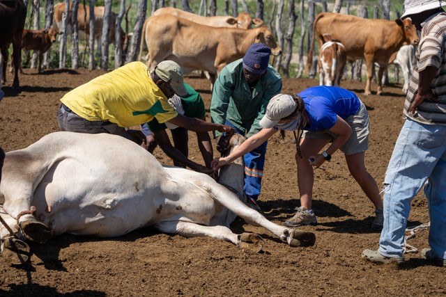
Image 2. Working with community members to put GPS trackers on cattle during routine ranching activities (Image by Dylan Feldmeier).
7) So, you were using the camera traps to see if the lions were there, but were you also asking about the lions in the interviews as well?
Yes, so that's a great question. I was doing this work with Dylan Feldmeier and Urmila Mallik
[2022 TRI Fellows and MESc ’23 graduates]. They came out with me for a portion of the time I spent in Botswana, so all of this work is in partnership with them.
In our interviews, we asked if they have had predation at their cattle post and where they thought predation was on the landscape with participatory mapping.
Dylan was specifically focused on going to the exact kill site locations and collecting information on the microhabitat of the kill site as well as variables that were driving why a predation event occurred or not. We found that there were several lion predation events that occurred while we were on the ground. We also know of lions that were shot in our study area during this time, so there certainly are lions there. But we weren't capturing any in the camera trap. I think part of that was because lions were coming out of the park, killing cattle, and then going back into the park.
So, they weren’t necessarily moving across the entire survey site of the corridor, but instead popping out and returning to the park. Many of the places that we know where the lions have been shot have also been on the edges of either national park. We found that this site is more of an unpassable matrix as opposed to a flow through movement.
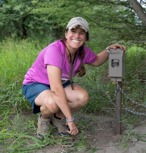
Image 3. Kaggie Orrick posing with one of her 80 camera traps she and her team systematically placed across the Makgadikgadi landscape (Image by Dylan Feldmeier).
8) Could you explain what a cattle post is?
A cattle post is a non-permanent structure where cattle are kept. A post has a very basic hut for a cattle herder to live in as well a semi-permanent fenced in area to enclose the cattle.
Cattle posts may or may not have water and cannot have electricity or any sort of plumbing. So, they are very basic but are placed across the landscape between the two national parks. No one really has spatial information of where these cattle posts are because they’re not permanent and can pop up anywhere. Because of the inconsistency and lack of geographic information, the cattle posts are not incorporated into any spatial models which makes it seem like a completely empty landscape. When in fact, there’s a lot of people who live in this landscape.
9) What personal experiences can you share that help us understand this problem and place better?
I think interviewing people and spending a lot of time on cattle posts with both herders and owners made it very clear that there's such a variety of attitudes towards wildlife.
There’s such a variety of needs and requirements that people are thinking of in terms of their day-to-day livelihoods. These needs are so varied and context-dependent that you really start to understand that the landscape is even more complex than just animals moving across it.
A negative or positive interaction is not necessarily captured with proximity to road or cattle post, as a spatial model might think. People move across this landscape at different times and have different requirements and feelings about wildlife at different times. It is difficult to capture this complexity in models. But it is also hard to not included people in any of the models because it is so clear that people drive so much of the conflict and interactions that occur in the landscape.
We had interactions where herders or cattle post owners would very proudly announce that they killed a lion as it was their right to do so. We also met other owners who said they would never hurt any sort of animal and even pump water for the elephants and birds so they could drink water at their posts. So, the practices across the landscape are really variable and everyone had different values which can also change at different times.
10) What are the critical challenges facing the communities at your research site?
There is a huge economic inequality that exists across Botswana, and I think it’s very apparent in this study area. There are ranches and cattle posts. I define ranches as not necessarily commercial, but kind of commercial where they sell to other places regionally but not broadly. There are many more cattle on ranches and they’re usually owned by affluent individuals who work for the government or in one of the many diamond mines in Botswana. Because they have a lot of wealth, they’re able to spread their ranches out. At the same time there are a lot of subsistence pastoralists who typically live in their cattle posts and have different needs and struggles.
There’s complexity within understanding how people need to survive and react to wildlife. If you are a subsistence pastoralist who only has a few cows and a lion eats one of them, that loss has a much larger effect on you compared to a wealthy rancher who may not notice one cow missing out of their 800 cattle.
The range of livelihoods that exist within the corridor are certainly one of the greatest challenges. I think there’s also a lot of tourism in the two national parks but not much job creation that exists for those living between the parks. So, there’s a divide of wealthy tourists who visit the parks and value the wildlife for sight-seeing and the residents living in the area who see the value of their cattle and worry about the wildlife harming their cattle.
11) What do you think is needed to understand or improve the situation?
I think that understanding the drivers behind people's attitudes and improving livelihoods is what will better this situation. Not only interviewing people and knowing where they live, but also trying to understand what strategies people would be interested in deploying for human-wildlife conflict, and what needs they are interested in conservation addressing.
The mitigation strategies for cattle post owners and herders might be different than the strategies that are best for the wealthier ranchers. So, trying to figure this out and incorporating that into any sort of conservation plan is critical.
12) What challenges did you experience in your research?
There are always so many challenges. I think one of the biggest challenges we had was navigating the landscape.
In the very beginning, I had mapped out all of the roads using Google Earth since there’s not many roads that existed in the area previously. I was planning on using these maps to place the camera traps, locate the cattle posts, and schedule interviews etc. When we got on the ground, we realized that the datasets we had from previous years were incorrect and the roads no longer existed. Some of the new roads that I had mapped also turned out to be just elephant trails instead of actual roads. So, we had spent a longer time than expected trying to just set up the first group of camera traps. It was difficult to maneuver across the landscape that has not been previously mapped and had very little data on it. We were working with local community members and Botswana colleagues, but it was still such a challenge.
Another fun challenge was driving around the landscape to set up camera traps and then accidentally falling into a hyena den that was dug underneath. So, the vehicle trouble was also a fun challenge!
But for the most part, there really wasn’t any struggle with working with people or interviewing people. We did a lot of outreach and networking beforehand and people in Botswana are just the kindest and were interested in the project. So, that part was really easy for us.
13) How do you want to use your research? How do you think your research will be used?
I've been working with the conservation organization Round River Conservation Studies and a tourism consortium called Natural Selection Tourism Organization. They’re very interested in moving forward with this project on how we can better support communities and connectivity throughout this landscape. So, my work is going to continue even after I graduate to figure out how to better assist the region across all entities.
I also hope that this is a template for how connectivity and conservation work can be applied to other places around the world. Although the findings of my project are context specific, the methodology and design of focusing on wildlife, human, and livestock practices can really help better understand what a coexistence landscape might look like.