Analyzing changes in Puerto Rican mangroves and local conditions to identify restoration opportunities
Analyzing Changes in Puerto Rican Mangroves and Local Conditions to Identify Restoration Opportunities
Adriana Colón Adorno, Yale College1
Abstract
Mangrove forests are extremely valuable to Puerto Rico (PR) and its residents. However, mangroves are one of the most endangered ecosystems of PR and account for less than 1% of the archipelago’s area. Mangroves are generally quite resilient and re-establish themselves once proper ecological conditions are restored. Therefore, the purpose of this study is to identify the areas on the main island of PR that have the potential to meet the ecological requirements of mangrove development and target these areas for restoration. The primary objective of this study is to recommend specific interventions for target areas of mangroves in PR. Based on the disturbed state of the majority of mangrove swamps observed in this study, mangrove conservation in PR would benefit from more active and deliberate monitoring and management. This report is valuable because of the focused and novel surveys conducted that can inform cost-effective interventions that have a high probability of success at increasing the area and health of mangrove forests in PR.
Los manglares son extremadamente valiosos para Puerto Rico (PR) y sus residentes. Sin embargo, los manglares son unos de los ecosistemas en peligro de extinción en PR y representan menos de 1\% del área del archipiélago. Generalmente, los manglares son sumamente resilientes y se recuperan adecuadamente cuando las condiciones ecológicas del medio ambiente se restablecen. Por lo tanto, el propósito de esta investigación es identificar las áreas de la isla principal de PR que tienen el potencial de satisfacer los requisitos para el desarrollo de los manglares, y enfocar en esas áreas para la restauración. El objetivo de la investigación es recomendar intervenciones específicas para las áreas más importantes de manglares en PR. Basado en el estado deteriorado de la mayoría de los manglares observados en la investigación, la conservación de manglares en PR se beneficiaría a través de monitoreo y manejo planificado estas áreas. Lo valioso de este reporte está en el estudio enfocado y novedoso que provee intervenciones económicas y efectivas con alta probabilidad de éxito para mejorar las áreas y salud de los manglares en PR.
Introduction
Mangroves, also called mangrove forests or mangrove swamps, are a specific type of permanently or frequently flooded wetland with woody vegetation (trees). The term mangroves can also refer more specifically to the trees that grow in these swamps, such as the species of Red Mangroves. Additionally, mangroves are a saline type of wetland, as opposed to freshwater wetlands, meaning they are physically connected in some way to ocean water.
Globally, mangrove forests are among the most productive and valuable ecosystems. Due to the generally anoxic conditions of their sediment (meaning either a partial or complete absence of oxygen), carbon is absorbed by the plants in these forests and stored in the soil at higher rates than nearly all other ecosystem types (The Blue Carbon Initiative, 2019). Existing along coastlines of the tropical and subtropical regions of the world, they also provide essential habitat for many migratory bird and marine species (Giri et al. 2010). In Puerto Rico (PR), mangrove forests are extremely valuable to the island nation and its residents. For example, they provide indispensable ecosystem services such as coastal protection from annual hurricanes, carbon sequestration, and wildlife habitat (Huxham et al. 2017). Beyond these ecological benefits, mangroves are also part of the foundation of a robust eco-tourism industry. Red mangroves create the world-famous bioluminescent bays of PR, where three of the world’s five bioluminescent bays are located. By capturing outflowing sediment, reducing erosion, and stabilizing the coastline, mangroves are also an essential part of maintaining the coastline and many beaches of PR (Ewel et al. 1998) which provide beautiful areas of enjoyment for residents and visitors alike.
However, mangroves are also one of the most endangered ecosystems of PR and account for less than 1% of the archipelago’s area (Martinuzzi et al. 2009), making their conservation very pressing. This current extent of mangroves is a 30% decline in area from their estimated coverage in 1800 (Spalding et al. 1997). Building on the work from previous studies (Martinuzzi et al. 2009, Lugo et al. 2014), the next step in the pursuit of restoring PR’s mangrove forests is to identify the areas on the main island that have the potential to meet the ecological requirements of mangrove development and target these areas for restoration. My paper aims to provide practical management recommendations for the improvement of specific Mangrove Areas of Interest (MAI) in PR.
Mangroves are generally quite resilient and re-establish themselves once proper ecological conditions, primarily hydrology, are restored (Holden et al., 2004). Therefore the purpose of this study is to identify areas on the main island of PR that have the potential to support mangrove restoration in order to recommend a management plan that could maximize the area and health of PR mangroves. I conducted field research during the summer of 2019 in order to address the following questions:
-
What is the spatial distribution of the changes in the area of mangrove forests in PR and which locations have experienced the most significant changes?
-
Which areas of PR have the most potential for improvement to satisfy the ecological requirements to support mangrove forests?
Through answering these questions, the objectives of this research project are as follows:
-
Ground truth remote-sensed satellite data on the location and size of mangrove stands in order to provide verified reports on land use and the coordinates of extant mangroves
-
Develop management recommendations specific to each MAI that can be used by government officials, local communities, organizations and private landowners.
General environmental protected areas and conservation initiatives currently exist in PR, though none are specific to mangrove conservation. There is also little-to-no management of the majority of mangrove areas in PR (Martinuzzi et al. 2009). This study is therefore based on the thesis that specialized, case-by-case attention to MAI is needed for the successful conservation and restoration of mangroves in PR. In the future, the research techniques and findings of this study can be scaled up and applied to other identified MAI. By focusing on 10 individual sites rather than trying to create a complete mangrove management plan for PR, this study can explore how systemic problems related to mangrove conservation manifest at the local level and how they can be addressed.
Background information
PR is an archipelago located in the Caribbean Ocean that consists of one main island and hundreds of smaller satellite islands. Only three of these islands are inhabited by people, including the main island, which is the focus of this study. The main island of PR has an area of 3,363 sq mi (8,710 km2) and a coastline of 311 mi (501 km) (Ellison et al. 1996). In PR, there are four species of mangroves: red mangrove (Rhizophora mangle L., Rhizophoraceae), black mangrove Avicennia germinans (L.) L., Acanthaceae), and white mangrove (Laguncularia racemosa (L.) C.F.Gaertn.) and button mangrove (Conocarpus erectus L.), both Combretaceae (Martinuzzi et al. 2009).
The current total area of mangroves in PR is approximately 8,323 hectares ( 32 square miles). This is compared to 11,791 ha ( 46 sq mi) of the estimated area of mangroves in 1800 and 14,825 ha ( 57 sq mi) of the estimated maximum extent, which is based on soil surveys (Roberts 1942). In the case of determining the historic range of mangroves in PR, looking specifically at soils with traces of salinity is very useful as this shows where ocean water interacted with the land in the past before being disturbed by human settlements and construction (Ariel Lugo, personal communication, 6 Aug. 2019).
Methodology
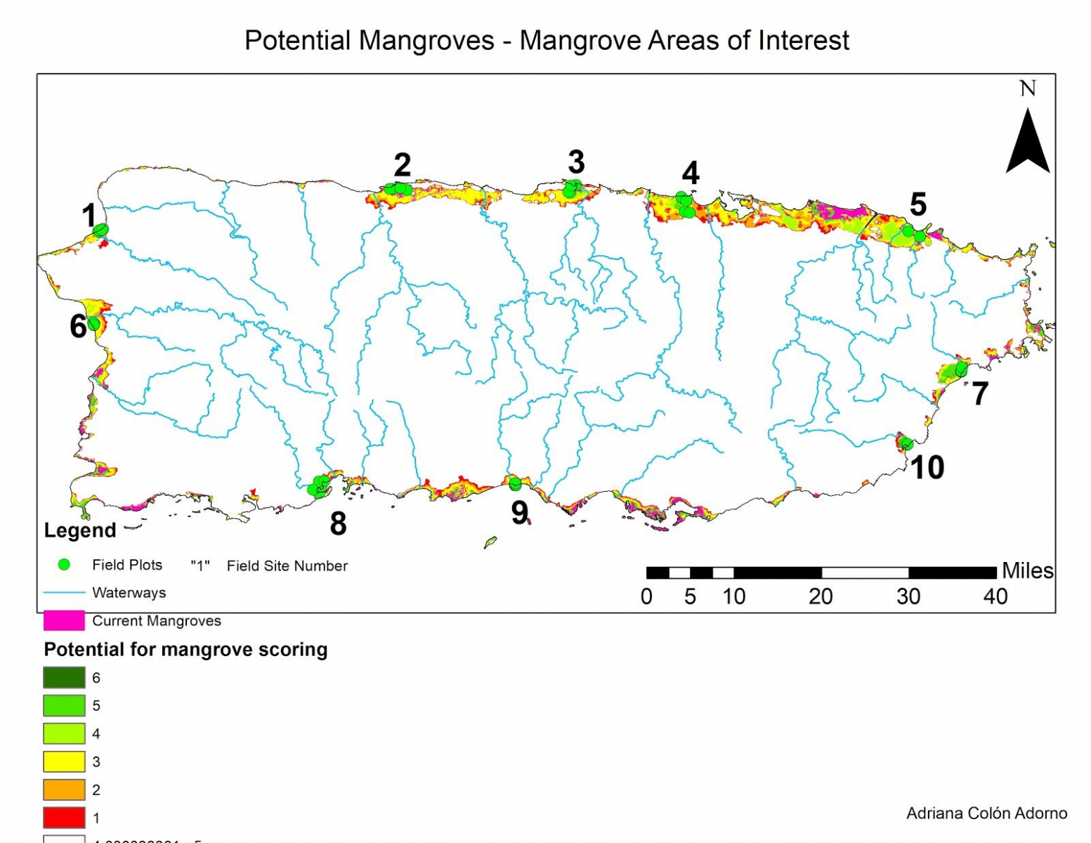
I created a map (Figure 1) through ArcGIS using satellite imagery and various sets of remote-sensing data (See Appendix B), which have been proven effective for monitoring changes in mangroves (Kovacs et al. 2001). This map combined an illustration of loss of mangroves since 1930 based on aerial images of PR and current ecological conditions relevant to mangrove survival including: elevation, groundwater hydrology, waterways, soil type (hydric versus non-hydric soils), surrounding land use and extant mangroves. The resulting map depicts the areas of PR which have the potential to support mangroves.
From this map, I selected 10 Mangrove Areas of Interest (MAI) to conduct my field research on. These sites were chosen based on which mangrove stands have experienced the most significant declines in area over the time period of my study (1930–2019) and which areas with the most potential to support more mangroves currently face the most disturbances to the relevant ecological conditions stated above. Visually, this was apparent in the spots with the largest difference between area of current mangroves and total area of potential mangroves. Within each MAI, I selected five field sites based primarily on remote sensing data about current land use. Three of the field sites (Sites A–C) were areas that contained mangroves, while the other two sites (Sites D, E) were nearby non-mangrove areas.
Once in the field, I collected data from five circular field sites with a diameter of 10 meters at each MAI. At each site, I recorded the true GPS coordinates and took photos facing the four cardinal directions (North, East, South, West) for future referencing. I also noted which, if any, mangrove species were present and any significant infrastructure or construction in or around the field site, such as drainage pipes, walkways, roads and ditches. Within the diameter of each field site I recorded: soil pH using a handheld pH meter, basal area using a manual gauge (bottlecap basal area gauge), diameter at breast height (DBH) of mangrove trees that were counted in the basal area measurement using an electronic caliper, height of the 10 tallest mangrove trees using a laser height gauge, percent canopy cover using a handheld densiometer, and water temperature and salinity (when water was present) using a handheld water sensor. For soil pH, water salinity and water temperature, I took three measurements for accuracy in random spots within the circular plot. I chose to collect these data based on the procedures used in various previous ecological mangrove studies in PR (Williams et al., 2013; Kovacs et al., 2001).
Results
A preliminary analysis of the field data collected (Table 2 in Appendix C) revealed that the field sites that contained mangroves were generally more similar to each other than they were to the non-mangrove field sites (Figure 1 in Appendix C). This was expected, but the analysis serves as a baseline confirmation that the mangrove field sites as compared to non-mangrove field sites all generally had similar ecological conditions, which was a basic assumption of the study design. Though I surveyed 10 MAI, for the purpose of this manuscript I will only discuss in detail the two locations labeled in Map 2 (See Appendix A) as Field Site 4 and Field Site 8 (correction: Field Site 4/8 are meant to be labelled as MAI 4/8). At every MAI except MAI 4 and one other, field observations and satellite images confirm the presence of drainage ditches, which are highlighted for MAI 8 with red lines in Image 3 (See Appendix D).
Mangrove Area of Interest 4
MAI 4 (see Image 1 in Appendix D) was mostly wetland, in the form of either red mangrove stands or wet grassland. There were some small patches of dry forest. The wetland was surrounded on all four sides by development of some sort. To the north, a built-up highway road separated the wetland from the ocean. To the east and south, residential development directly bordered the area. To the west, the land was cleared and used primarily for agriculture. A notable structure within the wetland was an elevated paved road, which cut off water flow within that part of the wetland, that leads out to a large, abandoned building on a cement platform in the middle of the flooded grassland. According to a resident who lives next to the wetland, this building is property of the US government, but there were no signs identifying the property, its purpose or ownership.
The wetland consisted mostly of tall grasses in flooded soil, but there were mangroves present directly along the edges of the bodies of water. These waterways included two main rivers, both stemming from one inlet from the ocean to the north. The river branch that flowed to the west appeared to taper off and be diverted into constructed ditches. The river branch that flowed to the east led into a lake which is bordered by residential developments.
Though there were a few live adult mangroves (categorized in my field surveys as being at least 10 feet tall) present throughout the area, living mangroves were nearly all young saplings. The majority of all tall, mature mangroves were dead with no foliage and often fallen over. In the areas where mangroves were visibly present, the water salinity was evidently high enough to sustain mangroves, which is supported by the water salinity samples collected (all above 10 ppt). However, there was generally a lack of available sediment for mangroves to root into. Either the water would quickly become too deep for mangroves to establish themselves or the surrounding construction, especially the road to the north of MAI 4, would increase the elevation of the sediment and prevent flooding. Both situations would result in a narrow strip of land which could support mangroves. In the wider areas of the wetland populated with grasses, water salinity levels were too low to support mangroves (below 0.5 ppt).
Mangrove Area of Interest 8
MAI 8 (see Image 2 in Appendix D) is vegetated primarily black and white mangroves, but there were also a few small stands of red mangroves. The land surrounding the mangroves was mostly cleared for agriculture, and there was also a small residential development to the northeast. Two farms owned this area, with one large farm primarily cultivating mango trees and the other smaller farm no longer growing crops, but still maintaining large cleared fields.
Throughout MAI 8, mangroves only grew along the water edge of the bay and along a small river and a few dug canals of water. On the southern outcropping of the area, a large gravel road ran through the small lake that is present, splitting it into two disconnected sides. On the north side of the road, there was a dense stand of black mangroves up until where the road increases the elevation of the sediment above the level of the flooding from the lake. There were only dead mangroves present to the south of the road in the area of water cut off from the north side. Construction also restricted the extent of mangroves at the main canal running along the edge of the smaller farm. One bank of the canal, which is an inlet to the harbor, was walled off with a cement wall, which prevented the water from flooding out onto the surrounding soil. The other side of the canal was not walled off, and there were red and black mangroves growing. The red mangroves were dominant towards the water’s edge and then transitioned into a stand of black mangroves. In another area of MAI 8, white mangroves were growing in a large stand in an area inland from the harbor. According to the owner of the smaller farm, the main river that flows through MAI 8, Rio (“River”) Yauco, still occasionally floods the farm when it overflows.
Recommendations
| MAI | Mangrove species present | Surrounding land use | Management recommendations |
|---|---|---|---|
| MAI 4 | Red | Residential; Non-saline wet grasslands | Redirect surface water runoff away from mangroves |
| MAI 8 | Red, black, white | Fruit farms; Salinas | Remove barricades around stream and mangrove area; Remove / alter paved roadway through mangroves; Fill drainage ditches |
At every MAI except MAI 4 and one other, field observations and satellite images confirm the presence of extensive drainage ditches. Therefore, a general large scale management recommendation is to fill these drainage ditches in order to restore the natural salt water hydrology of those areas. Drainage ditches negatively impact mangrove swamps, and often completely eliminate them, by channeling water that would otherwise uniformly flood the low-elevation area with saline water into deep ditches in order to contain the water and convert the floodplain into dry, arable land (Holden et al. 2004). These extensive drainage ditches are presumably leftover from wetland draining practices that commonly occurred in the early 19th and 20th centuries in PR. Filling them, although eventually necessary for mangrove restoration, would be a large and expensive undertaking. As such, whenever possible I have recommended additional management interventions based on my observations in order to provide more accessible and/or short-term mangrove restoration options.
Mangrove Area of Interest 4
Where water was present, salinity levels in the non-mangrove sites of MAI 4 were too low to support mangroves, at 0.29 ppt, compared to >10 ppt in the mangrove sites of MAI 4. This is likely a result of runoff from the surrounding residential and commercial areas flowing into the wetland at a higher rate than tidal action from the ocean introduces salt, thus diluting the water salinity levels. My primary management recommendation for MAI 4 is therefore to redirect surface water runoff from the surrounding residential and commercial areas so that they do not flow into the wetland and dilute the saline water flowing in from the ocean. This change could better allow the water salinity within the swamp to remain high enough to allow mangroves to outcompete other wetland plant species. The large abandoned building and its paved pathway in the center of the wetland could also be removed, but that would be a very expensive undertaking.
Mangrove Area of Interest 8
My primary management recommendation for MAI 8 is to remove and/or alter the existing infrastructure to facilitate proper tidal inundation. In the area of the smaller farm where there are no agricultural fields, the cement wall on the small canal can be removed to allow the saline water from the harbor to properly saturate the surrounding sediment. This change would create the conditions necessary for mangroves to take root in what are currently unused mudflats. In the southern part of MAI 8, the road could either be removed or flow pipes could be added beneath the road to allow water from the harbor to pass through and connect the two small bodies of water that currently flood the area. This change would allow new mangrove saplings to grow on the south side of the road.
Conclusion
Based on the disturbed state of all but one mangrove swamp observed in this study (located on the west coast of the main island), mangrove conservation in PR would benefit from more active and deliberate monitoring and management, and in some cases remediation to remove past disturbances or practices that are harmful to the mangrove stands. The purpose of this study is not to recommend new or untested methods of mangrove restoration, but to provide the observations needed to take the next step forward in actively restoring the mangrove swamps of PR. More detailed management plans could be designed through hydrological surveys of the MAI as well as financial analyses of the potential costs of implementing such measures. These management recommendations can be used by the private landowners of these areas, non-profit organizations working with the landowners, or the PRDNR.
Acknowledgements
I thank the Yale Tropical Resources Institute, the Yale Environmental Studies Department and Yale Trumbull College for funding this research project. I also thank Dr. Mark Ashton, of the Yale School of Forestry and Environmental Studies, and Dr. Ariel Lugo, the Director of the International Institute for Tropical Forestry, for the support and guidance they have offered me in the roles of my primary advisors in New Haven and Puerto Rico. Further thanks to Kealoha Freidenburg for serving as my advisor within the senior colloquium of the undergraduate Yale Environmental Studies department.
References
Giri, C. et al. 2020. Status and distribution of mangrove forest of the world using earth observation satellite data. Global Ecology and Biogeography 20, 154–159.
Ellison, A.M. and Farnsworth, E.J. 1996. Anthropogenic disturbance of Caribbean mangrove ecosystems: Past impacts, present trends, and future predictions. Biotropica 28, 549–565.
Ewel, K.C. et al. 1998. Different kinds of mangrove forests provide different goods and services. Global Ecology and Biogeography Letters 7, 83–94.
Holden, J. et al. 2004. Artificial drainage of peatlands: Hydrological and hydrochemical process and wetland restoration. Progress in Physical Geography: Earth and Environment 28, 91–123.
Huxham, M. et al. 2017. Mangroves and people: Local ecosystem services in a changing climate. pp 245–274. In: Rivera-Monroy et al. (eds.) Mangrove Ecosystems: A Global Biogeographic Perspective. Springer.
Kovacs, J. et al. 2001. Mapping disturbances in a mangrove forest using multi-date Landsat TM imagery. Environmental Management 27, 763–776.
Lewis, R.R. 1989. Creation and restoration of coastal wetlands in Puerto Rico and the U.S. Virgin Islands. pp 103–125. In: Kusler, J.A. & Kentula, M.E. (eds.) Wetland Creation and Restoration: The Status of the Science. U.S. Environmental Protection Agency, Environmental Research Laboratory, Corvallis, USA.
Lewis, R.R. 2005. Ecological engineering for successful management and restoration of mangrove forests. Ecological Engineering 24, 403–418.
Lugo, A. et al. 2014. Issues and challenges of mangrove conservation in the Anthropocene. Madera y Bosques 20, 11–38.
Martinuzzi, S. et al. 2009. Conversion and recovery of Puerto Rican mangroves: 200 years of change. Forest Ecology and Management 257, 75–84.
Spalding, M. et al. 1997. World Mangrove Atlas. International Society for Mangrove Ecosystems.
The Blue Carbon Initiative. 2019. About Blue Carbon. URL: https://www.thebluecarboninitiati ve.org/about-blue-carbon.
US Supreme Court. 1901. Downes v. Bidwell, 182 U.S. 244. No. 507, 27 May 1901, URL: https://supreme.justia.com/cases/federal/us/1 82/244/
Roberts, R.C. 1942. Soil Survey of Puerto Rico. U.S. Department of Agriculture, Bureau of Plant Industry.
Williams, C.O. et al. 2013. Hydrology and water quality of a field and riparian buffer adjacent to a mangrove wetland in Jobos Bay watershed, Puerto Rico. Ecological Engineering 56, 60–68.
Yaping, C. and Ye, Y. 2014. Effects of salinity and nutrient addition on mangrove Excoecaria agallocha. PLoS ONE 9, e93337.
Appendix A: Maps

Appendix B: Data sources
| Source | Publisher | Data provided | URL |
|---|---|---|---|
| Puerto Rico Coastal Digital Elevation Model | NOAA | PR elevation | https://catalog.data.gov/dataset /puerto-rico-coastal-digital-elevation-model3a94b |
| Mangrove Forests | Global Forest Watch | Existing mangroves in PR | https://www.arcgis.com/home /item.html?id=d9bad342fe4846 ecb83fc72b0e1fffe7 |
| Puerto Rico Gap Analysis Project | USDA Forest Service | Land use in PR | https://data.fs.usda.gov/geodata /other_fs/IITF/index.php |
| Soil survey, Puerto Rico | USDA Bureau of Plant Industry, University of Puerto Rico Agricultural Experiment Station | Hydric, Saline soils in PR | https://ufdc.ufl.edu/UF00016 128/00001/512x |
| USA Rivers and Streams | Esri | Waterways in PR | https://www.arcgis.com/home /item.html?id=8206e517c2264b b39b4a0780462d5be1 |
| Puerto Rico Municipality Boundaries | Esri | PR geographic boundaries | https://www.arcgis.com/home /item.html?id=80843fe57bde428 1b32e00d7bd89b3aa |
| US Wetlands Mapper | U.S. Fish and Wildlife Services | Wetlands in PR | https://www.fws.gov/wetlands /data/mapper.html |
| Georeferenced Aerial Images of PR, 1930 | 1930 aerial images of PR | http://www.prgeoref.org/ |
Table 3. Averages of field data for sites within MAI 4 and MAI 8.
Appendix C: Field data
| Site | Soil pH | Water Salinity | Water Temp. | Canopy Cover | Basal Area | DBH |
| (ppt) | (C) | (%) | (cm) | |||
| 4a | 5.87 | 15 | 26.33 | 94.25 | 20 | 80.87 |
| 4b | 5.93 | 15 | 31.37 | 72.75 | 35 | 145.03 |
| 4c | 5.8 | 15 | 30.2 | 90 | 20 | 82.22 |
| 4d | 6.4 | 0 | 0 | |||
| 4e | 6.27 | 0.29 | 28.1 | 0 | 0 | |
| 8a | 4.9 | 15 | 29.87 | 78.5 | 50 | 92.86 |
| 8b | 5.47 | 15 | 33.7 | 0 | 0 | |
| 8c | 6.33 | 15 | 27.73 | 82 | 20 | 110.93 |
| 8d | 5.73 | 0 | 0 | |||
| 8e | 6.53 | 0 | 20 | 73.89 |
Appendix D: Satellite images of Mangrove Areas of Interest
All MAI images are oriented with North being at the top of the photo. Blue checkpoints mark the location of the field sites within the MAI.


Citation
Colón Adorno, A. 2020. Analyzing changes in Puerto Rican mangroves and local conditions to identify restoration opportunities. Tropical Resources 39, 00–00.
-
Adriana Colón is …↩